New and Updated Data (2026)
![]() Updated
by
PolicyMap
Updated
by
PolicyMap
Date | Type | Details | Category |
07/20/2027 | Updated Data | Data layers on Energy Community designations have been updated in PolicyMap through the 2026 eligibility criteria. These include one county-level designation based on historical Fossil Fuel Employment and current rates of unemployment, and then a separate census tract-level designation based on closure of coal mines or coal-burning electric generation units. | Curated Collection > Clean Energy Tax Incentives |
07/17/2027 | Updated Data | Migration data from the IRS has been updated to 2022 data. | Demographics > Migration > Annual Migration |
07/10/2026 | Updated Data | PolicyMap and Quantitative Innovations Medical Spending Estimates have been updated to 2023. Updates: This dataset relies on underlying ACS data, which is why we've previously only shown the most recent year available. In this update, we added logic to show two non-overlapping ACS periods (paired with the corresponding AHRQ Medical Expenditure Panel Survey data for each), users can now see trend charts rather than just a single snapshot. The indicator descriptions and data sources pages have been updated for clarity. | Income and Spending > Medical Spending Estimates Health > Costs and Insurance > Medical Spending Estimates |
07/07/2026 | Updated Data | CMS Medicare Accepting Provider locations have been updated to the most recent 2026 data. | Health > Health Facility Locations > Medicare Accepting Provider Locations Health > Access to Medical Care > Medicare Accepting Provider Locations |
07/01/2026 | Updated Data | The Cost of College dataset has been fully refreshed and updated to the 2023-2024 school year, now with broader institutional and degree-level coverage. What's new:
Methodology: Estimates use NCES IPEDS data and reflect enrollment-weighted averages, where each institution's published tuition and/or fees is weighted by full-time enrollment, so larger institutions contribute proportionally more. Estimates cover tuition-only and tuition-and-fees (sticker price) measures, and reflect sticker prices only (no grants, scholarships, or aid). Institutions missing tuition or enrollment data are excluded from weighting. State-level aggregates display as "Insufficient data" when coverage is incomplete. | Education> Cost of College |
06/23/2026 | Updated Data | The Surgo Ventures Maternal Vulnerability Index (MVI) data has been updated on PolicyMap for the latest release of the 2025 data. | Health > Risk Factors > Maternal Vulnerability |
06/22/2026 | Updated Data | The locations of properties participating in the Low-Income Housing Tax Credit (LIHTC) program by HUD have been updated to 2024 data. | Housing > Housing Locations |
06/16/2026 | Updated Data | The National Center of Education Statistics (NCES) point datasets for Four-Year Colleges and Universities and Community Colleges have been updated with the 2023–2024 School Year data. | Education > Education Locations |
06/12/2026 | Updated Data | Drug and Alcohol Treatment Facility and Mental Health Treatment Facility locations from the Substance Abuse and Mental Health Services Administration (SAMHSA) have been updated to 2024 data. During this update, our team learned that SAMHSA’s Buprenorphine Treatment Physician data has been decommissioned and is no longer available. | Health > Health Facility Locations |
06/12/2026 | Updated Data | BLS Local Area Unemployment (LAU) monthly statistics data have been updated through April 2025. The BLS annual 2025 data have been updated as well. Please note that October 2025 data is unavailable due to a lapse in federal appropriations, except for Puerto Rico. | Economy > Employment and Unemployment |
0605/2026 | Updated Data | Annual and Quarterly Home Sales data from Black Knight have been updated to 2025 and 2026Q1. | Housing > Home Sales |
06/03/2026 | Updated Data | The Consumer Financial Protection Bureau (CFPB) rural or underserved counties have been updated to include 2025 and 2026 and is available to all users. When updating, some discrepancies were noticed, and PolicyMap reached out to the CFPB. The CFPB responded with a note that this dataset reflects rural and underserved designations at the county level. However, under 12 CFR Section 1026.35(b)(2)(iii)(D)(2), an area may also qualify as rural if it is located in a census block that is not within an urban area, as defined by the U.S. Census Bureau using the most recent decennial census. Lenders should also use the CFPB Rural or Underserved Areas Tool, which provides a more comprehensive determination of rural status and a safe-harbor determination that a property is located in a rural or underserved area as defined in 12 CFR 1026.35(b)(2)(iv)(A) and (B). | Federal Guidelines > Additional Federal Guidelines > Economic Development Designations > CFPB Rural or Underserved Counties |
05/26/2-26 | Updated Data | The Lead Exposure Risk Index has been updated to the current ACS time frame and is available to all users under the Housing menu. This update aligns the data with the Washington State Department of Health's current methodology, using newer housing survey data to better reflect lead paint risk by housing age. | Housing > Residential Buildings and Quality > Housing Quality |
05/26/2026 | Updated Data | CDC mortality data for disease-related deaths and injury deaths have been updated for 2024. | Health > Vital Statistics > Mortality > Disease-Related Deaths > Injury Deaths Curated Collections > Social Determinants of Health > Life Expectancy and Mortality > Adult Mortality |
05/07/2026 | Updated Data | CRA small business and small farm loan data is updated through 2024. Notes: This is the first year the data reflects the 2022 boundaries, so Connecticut does not have percent-change data available for 2024. | Lending |
05/04/2026 | NEW DATA | The predominant foreign-born data was updated to the 2020-2024 Census ACS. This category includes several new countries of birth, including Algeria, Azerbaijan, Bhutan, Georgia, Ivory Coast, Marshall Islands, St Lucia, Tanzania, Togo, and UAE. | Demographics > Foreign Born Population, Immigration > Foreign Born |
05/04/2026 | Updated Data | PolicyMap’s Home Ownership and Renter Affordability estimates have been updated with the new 2020-2024 ACS data. | Housing > Affordability and Cost Burdens > Affordability |
04/30/2026 | Updated Data | Infant Death data from the CDC has been updated to 2023. | Health > Vital Statistics > Mortality > Infant Mortality |
04/24/2026 | NEW DATA | American Community Survey (ACS) celebrates its 20th anniversary! This update adds the 10-year percent change indicators comparing the periods 2005-2009 and 2020-2024. From demographics and community composition to housing costs and family characteristics, new indicators added include the following: New Census Tables:
New Indicators: Demographics
Children & Families
Income
Housing
| All Categories |
04/24/2026 | Updated Data | Area Median Income (AMI) data from the Department of Housing and Urban Development (HUD) has been updated to 2025 data. Included in this update is metro area and state-level data, available from 2017 onward. For some metro areas, HUD publishes an AMI for each county rather than one AMI for the whole area. To ensure data accuracy, we have decided to only include metro areas with a single AMI | Incomes & Spending > Income >Area Median Income |
04/13/2026 | Updated Data | Birth data from the CDC has been updated to 2024. This update includes a change to the indicator “Less than Recommended 8 Prenatal Visits”, which has been renamed to “8 or Fewer Prenatal Visits”. This indicator was changed due to how the CDC collected prenatal visit data, forcing us to switch it from less than 8 visits to 8 or less visits. Further, the dev team decided to remove the “Recommended” in the taxonomy after finding new guidance from The American College of Obstetricians and Gynecologists, which states that the number of prenatal visits a mother needs should be individualized, rather than a baseline number. This information has been included in the data directory. | Health > Vital Statistics > Birth and Prenatal Care |
04/13/2026 | Updated Data | Select Health Professional data from BLS Occupation Employment and Wage Statistics (OEWS) is now available on PolicyMap. Specifically, the count, rate, and wages for Community Health Workers, Healthcare Social Workers, and Health Education Specialists. | Health > Access to Medical Care > Health Professionals |
04/09/2026 | Updated Data | Tracts that are considered eligible low-income communities (LIC) for the new round of Opportunity Zone designations have been added to PolicyMap. This data is from the US Dept of the Treasury. States will select up to 25% of eligible LICs to be nominated as Qualified Opportunity Zones. The graphic below, from Novogradac, lays out the timeline for the OZ 2.0 nominations and when the official designations will go into effect (Jan 1, 2027). 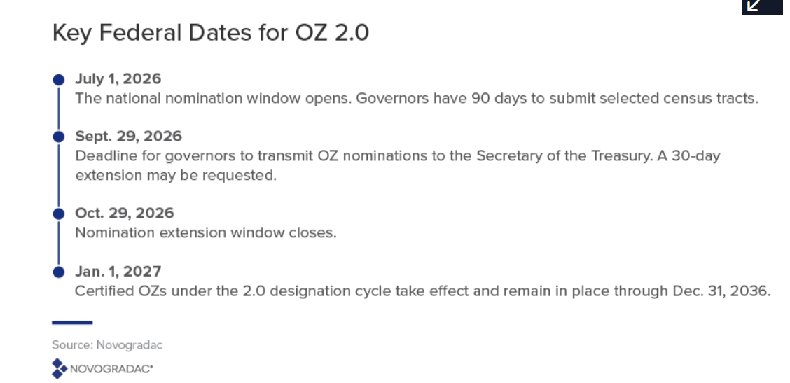 | Federal Guidelines > Additional CDFI Fund Programs > Opportunity Zones |
04/09/2026 | Updated Data | The HRSA Community Health Centers and Look-Alikes point data has been updated on PolicyMap. This dataset includes community health centers receiving federal grants and those that are eligible but not currently receiving grant funding. Although they are not receiving grants, these providers, or look-alikes, are eligible for some benefits, including enhanced reimbursement from Medicare and Medicaid. Mapping both FQHCs and look-alikes can provide a fuller picture of the health-care safety net in a community. The list and locations of FQHCs and look-alikes were obtained from HRSA in March 2026. Patient demographics and site performance data is from the Uniform Data System latest 2024 data. The UDS data is released on a different schedule than the HRSA FQHC and look-alikes data. The data source suppressed health center confidential data and patient counts between 1-15 to protect patient privacy. The dataset is comprised of two different sources. We have pulled the latest data from each. Please note that this point dataset is different from our suite of HRSA Facilities (e.g., Hospitals, FQHCs, Home Health Agencies, Nursing Facilities, Psychiatric & Community Mental Health Services, Other Health Facilities). | Health > Health Facility Locations > Community Health Centers and Look-Alikes |
04/06/2026 | NEW DATA | CMS Medicare Advantage Enrollment data is now available on PolicyMap. This monthly dataset provides state- and county-level enrollment numbers for all Medicare Advantage plans. | Health > Costs and Insurance > Medicare |
04/06/2026 | NEW DATA | New point data displaying the locations of pharmacies enrolled in HRSA’s 340B Drug Pricing program have been uploaded to PolicyMap. The 340B Drug Pricing Program allows eligible health care organizations (covered entities) to purchase outpatient drugs from manufacturers at significantly reduced prices. These covered entities then contract with retail pharmacy partners to dispense the discounted medications to patients. This new dataset displays the locations of these pharmacies and information on the covered entities they are contracted with. | Health > Health Facility Locations > Pharmacies Enrolled |
03/30/2026 | NEW DATA | New cancer incidence data from the North American Association of Central Cancer Registries (NAACCR) is now available for select head and neck cancers. | Health > Health Conditions > Cancer |
03/24/2026 | Updated Data | HRSA's Federal Office of Rural Health Policy (FORHP) Rural Status is a new dataset that is now available on PolicyMap. | Health > Access to Medical Care > Rural Status |
03/19/2026 | Updated Data | ACS & PolicyMap's Median Age Percentile Rank dataset has been updated with the newest 2020-2024 Census data. | Demographics > Age |
03/19/2026 | Updated Data | The USDA Rural Urban Continuum Codes (RUCC) data have been updated to reflect their latest 2023 data. The RUCC system provides 9 categories describing how rural or urban an area is and its relationship to larger metropolitan regions. | Federal Guidelines > Additional Federal Guidelines Health > Access to Medical Care |
03/16/2026 | Updated Data | Flood Maps have been updated on Production, with FEMA data as of March 2026. The flood zone layers show which areas have been defined as flood hazard areas on Flood Insurance Rate Maps. For ease of interpretation, PolicyMap has translated the flood zone designations into High, Moderate, Minimal and Undetermined risk of flooding. The granular Flood Zone designations are available in the indicator bubble. Areas with increased coverage include:
| Quality of Life > Environment and Disaster Risks > Flood Risks |
02/26/2026 | UPDATED DATA | Data Updated on PolicyMap: 2020-2024 Census American Community Survey (ACS). This is the first year we have four non-overlapping time periods with the data going all the way back to 2009. | Demographics, Incomes & Spending, Housing, Health, Quality of Life, Economy, Education, Federal Guidelines |
02/04/2026 | Updated Data | Minimum wage data by state from the U.S. Department of Labor has been updated for 2026. Please note that American Samoa has special minimum wage laws that are not mapped but detailed here. In addition, some municipalities and counties have a minimum wage higher than the state's, but those are not distinguished on the map since it is state-level. Find more info in the data sources . | Incomes & Spending > Income > Minimum Wage |
01/28/2026 | Updated Data | The CDFI Fund Certified CDFI point dataset has been updated on production for their latest January release. The points show where Certified CDFI organizations are located, the type of organization, and if it is a native CDFI. Please note that all PO Boxes are excluded from geocoding. | Lending > CDFI Fund Locations > Certified CDFIs |
01/27/2026 | Updated Data | BLS Local Area Unemployment (LAU) monthly statistics data have been updated through September 2025. | Economy > Employment and Unemployment |
01/09/2026 | Updated Data | SNAP Retailer location data from the USDA has been updated to 2025. | Quality of Life > Quality of Life Locations > SNAP Retail Locations Health > Food Access Locations > SNAP Retail Locations |
01/07/2026 | Updated Data | CDC PLACES data has been updated through 2023. All Teeth Lost indicator was added to production, and confidence intervals were added to the Info Bubbles. Release Notes Depending on the indicator, most are released for 2023, a few are discontinued (see description), and these five indicators are re-released for 2022--> Colorectal cancer screening, Mammography, Short sleep duration, Dental visit, and All teeth lost. Notes: PA and KY are missing data for all of 2023, FL is missing in 2021, and NJ is missing in 2019. | Health > Health Conditions > Chronic Conditions Health > Risk Factors06 |