Share
![]() Updated
by
PolicyMap
Updated
by
PolicyMap
The Share feature allows users to quickly and easily share an interactive map with others. A shared map can be panned around, zoomed further into a neighborhood, and view data for surrounding geographies.
Link—Quickly generate a link to share an interactive map. The link will open the map centered on your current location, display any data currently loaded, and any filters placed.
Email—The email feature sends a link to any recipient, even if they are not a PolicyMap subscriber. Users can include a message with the link. The recipient will receive an email with the same URL as the Link feature.
Embed—Add a fully interactive map onto your website with the Embed function of Share.
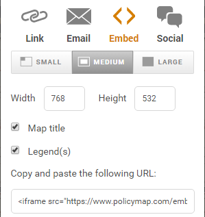
You can choose from three (3) sizes based on pixel dimensions for the interactive map: small (560W x 450H), medium (786W x 532H), and large (1280W x 720H).
Embedded maps are delivered as an "iframe code," so the HTML for an embedded map could look like this:
<iframe src="https://www.policymap.com/embedmap_dyn?lqid=237782" named="embeddedmap" scrolling="no" marginheight="0" marginwidth="0" frameborder="0" width="1024" height="500" >Click here to interact with map.</iframe>
There are some limitations to the embed map feature:
Social—Quickly publish a map you created in PolicyMap on various social media apps.