Data Loading and Geocoding: Part I
![]() Updated
by
PolicyMap
Updated
by
PolicyMap
Geocoding is the process of finding latitude and longitude coordinates for a point or address. Geocoding plays an important role in PolicyMap’s Data Loader, and it’s important that you understand how it works, and what you can do to find points when PolicyMap can’t.
The Data Loader has a good automatic geocoder. When you upload a spreadsheet of data onto PolicyMap, the geocoder takes each of the addresses in your table, and finds latitude and longitude coordinates for them. If you upload a spreadsheet of 100 addresses, it can usually find 80-90 of addresses.
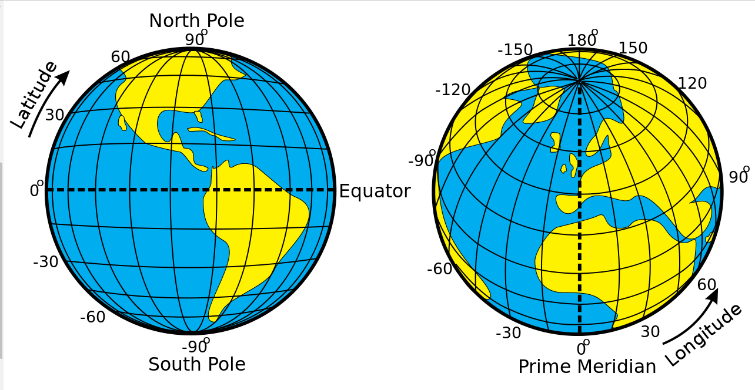
What are latitude and longitude numbers? If you are facing the equator and the prime meridian (a point somewhere off the coast of western Africa), the latitude number is the angle you’d have to look up to see your point on the surface of the Earth, and the longitude is the angle you’d have to turn to the right or left. Since the United States is in the Northern and Western Hemispheres, its latitude will always be a positive number of degrees and its longitude will always be negative.
As an example, I’ve uploaded a spreadsheet of public libraries in Pennsylvania. As you can see, we have lots of green circles, meaning it was able to find those points:
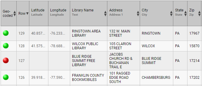
In this case, it wasn’t able to find the red circle because it was a cross of two roads, which our geocoder cannot find. In other cases, it can’t find addresses because they might be a PO Box, spelled wrong, have the wrong zip code, or be so new, it’s not in our geodatabase yet.
Read our suggestions in setting up a file here.